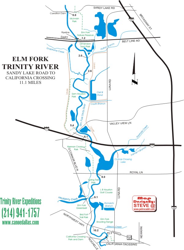
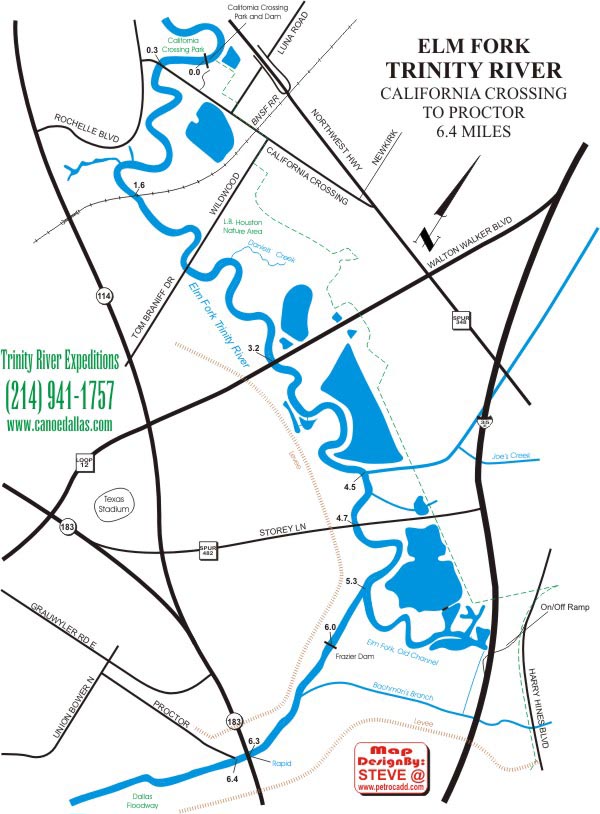
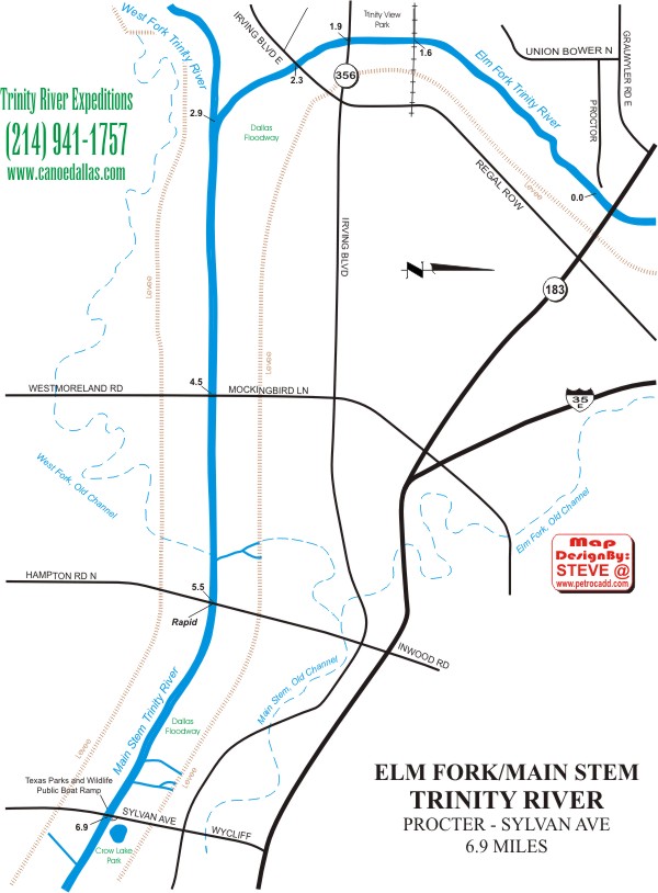
 The Elm Fork of the Trinity flows south from Lake Lewisville, parallel to
I-35E, until it meets the West Fork and becomes the Trinity Main Stem.
The
Elm Fork flows between steep banks of floodplain soils and occasional
shale outcrops, and is generally bordered by wooded bottomland. Bird watching
is excellent, and wildlife sightings include beaver, musk
turtles, diamondback water snakes and bobcats. A number of tributaries
flow into the Elm Fork, including Denton Creek, and in some areas the
river is connected to small lakes and ponds. There are trips from 3 to 10
miles in length on 29 miles of the Elm Fork, most of which has a
dependable flow all year. Between Frazier Dam and Trinity View Park, river
levels are often too low for boating. There are a series of small riffles
between Lake Lewisville and Highway 121-Business Route, and one small
rapid beneath Highway 183 in the Dallas Floodway. There are 3 dams and (at
least) one log jam that must be portaged on the Elm Fork. Carrollton Dam
is beneath the Sandy Lake Road bridge, California Crossing Dam is at
California Crossing Park in Dallas, Frazier Dam is at the entrance to the
Dallas Floodway and a perennial log jam is located upstream of Belt Line
Road beneath a railroad trestle.
The Elm Fork of the Trinity flows south from Lake Lewisville, parallel to
I-35E, until it meets the West Fork and becomes the Trinity Main Stem.
The
Elm Fork flows between steep banks of floodplain soils and occasional
shale outcrops, and is generally bordered by wooded bottomland. Bird watching
is excellent, and wildlife sightings include beaver, musk
turtles, diamondback water snakes and bobcats. A number of tributaries
flow into the Elm Fork, including Denton Creek, and in some areas the
river is connected to small lakes and ponds. There are trips from 3 to 10
miles in length on 29 miles of the Elm Fork, most of which has a
dependable flow all year. Between Frazier Dam and Trinity View Park, river
levels are often too low for boating. There are a series of small riffles
between Lake Lewisville and Highway 121-Business Route, and one small
rapid beneath Highway 183 in the Dallas Floodway. There are 3 dams and (at
least) one log jam that must be portaged on the Elm Fork. Carrollton Dam
is beneath the Sandy Lake Road bridge, California Crossing Dam is at
California Crossing Park in Dallas, Frazier Dam is at the entrance to the
Dallas Floodway and a perennial log jam is located upstream of Belt Line
Road beneath a railroad trestle.